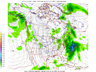
The GFS model for the next 16 days indicates that there continues to be a northern storm track across the Great Lakes and into the St. Lawrence River Valley. Another strong low is forecast to generate strong winds around March 10, 2012.
George Wright is a Certified Consulting Meteorologist for Wright Weather Consulting, LLC. Our website is WrightWeather.com.George is also a meteorologist with ABC News and Cablevision News 12.
Sunday, February 26, 2012
Strong Wind Gusts Today in the New York City Metro Area
A strong low pressure system produced wind gusts up to 59 mph in Eatons Neck, Long Island and 55 mph in Neptune Park, CT. Central Park recorded 41 mph and a wind gust of 51 was measured at La Guardia Airport. Snow showers and flurries also occurred - during the afternoon flurries were falling and the air temperature was 42-43 degrees which is unusual. Later in the day the temperature cooled into the mid to upper 30s with snow showers and flurries during the evening. No accumulations were reported.
George Wright is a Certified Consulting Meteorologist for Wright Weather Consulting, LLC. Our website is WrightWeather.com.George is also a meteorologist with ABC News and Cablevision News 12.
George Wright is a Certified Consulting Meteorologist for Wright Weather Consulting, LLC. Our website is WrightWeather.com.George is also a meteorologist with ABC News and Cablevision News 12.
Friday, February 10, 2012
Progessive Pattern Continues Over the US...1-2" of Snow Possible in NYC More Alaskan Snow
This winter pattern has been influenced by La Nina and also a highly positive Artic Oscillation and North Atlantic Oscillation. Snowfall over most of the lower 48 states is well below normal. Syracuse is running about 40 inches below normal. A strong upper vortex over easter Canada will generate spokes of positive vorticity across the Great Lakes to the Mid-Alantic states through tomorrow. A weak low will form off the coast of North Carolina and it will then track northeast off the coast. An Arctic front will push through on Saturday generating snow showers. As much as 1 to 2 inches of snow is forecast for NYC with a mix with rain to the south across Central New Jersey. Up to 3" will fall across Long Island and as much as 4" in southeast Connecticut. Since the pattern is progressive, the cold will not last and temperatures will be above normal by Tuesday and Wednesday. Several more snowstorms are forecast in Alaska over the next two weeks.
George Wright is a Certified Consulting Meteorologist for Wright Weather Consulting, LLC. Our website is WrightWeather.com.George is also a meteorologist with ABC News and Cablevision News 12.
George Wright is a Certified Consulting Meteorologist for Wright Weather Consulting, LLC. Our website is WrightWeather.com.George is also a meteorologist with ABC News and Cablevision News 12.
Sunday, February 5, 2012
Colder Weather Possible for the Northeast and the Great Lakes in the 2nd Half of February 2012
The longer range weather prediction models indicate that the weather is forecast to turn colder for the Great Lakes and the Northeast with continued above normal temperatures for the western third of the nation. Some of the models indicate a chance of rain or snow, sleet and freezing rain on or about February 10-12, 2012. The ECMWF forecasts a brief cold spell for the Northeast in 168-192 hours and then a rapid warmup in 240 hours.
George Wright is a Certified Consulting Meteorologist for Wright Weather Consulting, LLC. Our website is WrightWeather.com. George is also a meteorologist with ABC News and Cablevision News 12.
George Wright is a Certified Consulting Meteorologist for Wright Weather Consulting, LLC. Our website is WrightWeather.com. George is also a meteorologist with ABC News and Cablevision News 12.
Subscribe to:
Comments (Atom)


