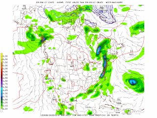
Autumn officially arrived today at 10:49 a.m. EDT. The weather was mild with a few showers and thunderstorms across the Northeast and New York City. Late this afternoon a brief shower occurred in the city. The GFS model is indicating a relatively quiet pattern over the first two weeks of autumn across the Northeast and the Upper Midwest. However, the period begins with a relatively strong vortex or upper-level low over the Great Lakes and Ontario that produces scattered showers and storms across the Northeast and the Great Lakes. The vortex quickly lifts into eastern Canada and the flow becomes mostly zonal or west to east over most of the lower 48 states by Saturday, September 29, 2012.
By Wednesday, October 3, 2012, the GFS model is forecasting another cut-off low or vortex to dig across southern central Canada into the upper Midwest. At this point, the model is bringing a potential tropical storm system up along the eastern seaboard with a soaking rainmaking storm cross near Long Island on October 3, 2012. The vortex over the upper Midwest creates a southerly flow at 500 mb that could steer a tropical storm system up the coast. Of course, this more than one week away and this forecast will likely change in the next several days. After this potential coastal or tropical storm event, the upper-low quickly lifts into eastern Canada and the flow becomes more zonal by October 6, 2012. Let's see how this forecast changes in the coming days.
George Wright is a Certified Consulting Meteorologist for Wright Weather Consulting, LLC. Our website is WrightWeather.com. George is also a meteorologist with ABC News and Cablevision News 12. Follow George Wright on Twitter.


