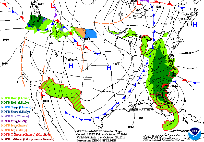
The eye of Matthew is now off the coast near Daytona Beach and is forecast to remain offshore of Florida. This will keep the very strongest winds from hitting the coast. However, wind gusts over 90 or 100 mph will still occur. Thirty foot waves have been reported at the buoy 20 miles southeast of Cape Canaveral. Very strong Category 3 storm Matthew continues to hug the coast of Florida. Vero Beach reported a 74 mph gust at 4:00 a.m. today. At 8:00 a.m. the storm is located approximately 45 miles to the east-southeast of Daytona Beach, 120 maximum sustained winds, north-northwest movement at 12 mph, central pressure 27.86 inches. The storm is forecast to move along the coast to Jacksonville and then to coastal Georgia and the Carolinas this weekend. This is the official advisory from the National Hurricane Center:
DISCUSSION AND 48-HOUR OUTLOOK
At 800 AM EDT (1200 UTC), the eye of Hurricane Matthew was located
near latitude 28.9 North, longitude 80.3 West. Matthew is moving
toward the north-northwest near 13 mph (20 km/h), and this general
motion is expected to continue today. A turn toward the north is
expected tonight or Saturday.
On the forecast track, the center of
Matthew will be moving near or over the east coast of the Florida
peninsula through tonight, and near or over the coasts of Georgia
and South Carolina on Saturday.
Maximum sustained winds are near 120 mph (195 km/h) with higher
gusts. Matthew is a category 3 hurricane on the Saffir-Simpson
Hurricane Wind Scale. Although weakening is forecast during the
next 48 hours, Matthew is expected to be a category 3 hurricane as
it moves near the coast of Florida today.
Hurricane-force winds extend outward up to 60 miles (95 km) from
the center, and tropical-storm-force winds extend outward up to 185
miles (295 km). Cape Canaveral recently reported and wind gust to
97 mph (155 km/h), and Daytona Beach reported a wind gust of 67 mph
(110 km/h).
The latest minimum central pressure reported by the reconnaissance
aircraft was 944 mb (27.86 inches).
Winds increase rapidly in elevation in a tropical cyclone.
Residents in high-rise buildings should be aware that the winds at
the top of a 30-story building will be, on average, about one
Saffir-Simpson category higher than the winds near the surface.
Tropical storm conditions are expected in the tropical storm warning
area in the Carolinas tonight and Saturday.
STORM SURGE: The combination of a dangerous storm surge, the tide,
and large and destructive waves will cause normally dry areas near
the coast to be flooded by rising waters moving inland from the
shoreline.
The water could reach the following heights above ground
if the peak surge occurs at the time of high tide...
Sebastian Inlet, Florida, to Edisto Beach, South Carolina, including
portions of the St. Johns River...7 to 11 ft
Edisto Beach to South Santee River, South Carolina...4 to 6 ft
Jupiter Inlet to Sebastian Inlet, Florida...4 to 6 ft
South Santee River, South Carolina, to Cape Fear, North Carolina...2
to 4 ft
George Wright is a Certified Consulting Meteorologist for Wright Weather Consulting, LLC. Visit our website at WrightWeather.com. Follow George Wright on Twitter @gwweather.