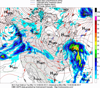
The Blizzard Warning continues for the interior suburbs of New York City into New England. The Blizzard Warning for the city and Long Island was discontinued early this morning as warmer air moved in from the ocean. The NAM model once again forecasted the storm very well and indicated that there would be a changeover to sleet and rain across Long Island and the city. The NAM first correctly forecasted that the track of the storm would be closer to the New Jersey coast which allowed for warming in the upper levels of the atmosphere. There was a period of heavy sleet for 3 or 4 hours this morning in Central Jersey and the city. The sleet changed back to snow by 11 a.m. Radar shows that the snow should end in the mid-afternoon. Unlike last years major snowstorm in January 2016, the weather after this storm will be colder than normal which will keep the snow around on the ground into the Spring season. Peak wind gusts so far include 45 mph at Bridgeport, 43 mph at Newark, 35 mph in Central Park, 45 mph in Montauk. At 11:00 a.m., sleet/snow is falling in Central Park, 31, snow in Linden, 30, rain in Toms River, 36, heavy rain in Westhampton, 40, heavy snow in Albany, 21. The storm is located east of New Jersey, it will move northeast to Cape Cod this evening. Snowfall amounts so far include 13.0 inches in Mahwah, 8.0 inches in Ringwood, 11 inches in Monroe, 11.1 inches in Pearl River, 3.5 inches in North Babylon. There may be a few snow showers or flurries tonight and tomorrow, otherwise the weather will be unseasonably cold through Friday. There is a chance of some light snow or rain this weekend.
George Wright is a Certified Consulting Meteorologist for Wright Weather Consulting, LLC. Visit our website at WrightWeather.com. Follow George Wright on Twitter @gwweather.


