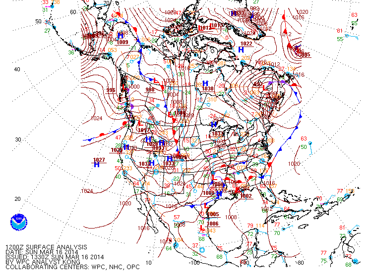
Low pressure is tracking across Arkansas this morning. This system has spread an area of snow, sleet and freezing rain form northeastern Oklahoma to southwest Indiana. A large area of rain and embedded thunderstorms extends from eastern Oklahoma across the Tennessee River Valley and the Southeast. There is an area of heavy thunderstorms along the associated cold front from north-central Georgia to southeast Louisiana. Tornado watches and warnings are now in effect for portions of the Florida Panhandle, extreme southern Mississippi and southern Alabama. Here is one of the tornado warnings that are currently in effect from the NWS office in Mobile, Alabama:
SEVERE WEATHER STATEMENT
NATIONAL WEATHER SERVICE MOBILE AL
941 AM CDT SUN MAR 16 2014
A TORNADO WARNING REMAINS IN EFFECT UNTIL 1015 AM CDT FOR NORTHERN OKALOOSA COUNTY... AT 935 AM CDT...NATIONAL WEATHER SERVICE DOPPLER RADAR CONTINUED TO INDICATE A TORNADO. THIS TORNADO WAS LOCATED NEAR ROCKCREEK...OR 16 MILES NORTHWEST OF CRESTVIEW...MOVING EAST AT 45 MPH.
The Storm Prediction Center has included portions of the central Gulf coast in an elevated risk area for severe weather today. An elevated area for severe weather is forecast to across central Florida on Monday. The low is forecast to track to the east near North Carolina by Monday evening. The National Weather Service has issued winter storm warnings and advisories from northern Arkansas/southern Missouri to western North Carolina and southern New Jersey. Only a dusting or flurries are forecast for the New York City metropolitan area on Monday. Washington, D.C. is expecting 3 to 6 inches of snow with up to 4 inches for Atlantic City. Up to a foot of snow is forecast in the mountains of northern Virginia and West Virginia.
A storm system that spread rain this weekend to Washington will move eastward spreading heavy mountain snows across the northern Rockies into tonight. This system will intensify into a storm that will track across the northern plains to the Great Lakes by Wednesday and into eastern Canada by Thursday. Snow and strong winds can be expected Tuesday and Wednesday from the northern Rockies to the Great Lakes.
It is interesting to note that there was a wide difference in the NAM model runs and the GFS model runs during the last two model cycles. The NAM was producing a strong, compact low pressure system moving along the East Coast spreading heavy rain and strong winds into New York City and southern New England by Wednesday. However, the latest 12 Z NAM is now more in line with the GFS and keeps this system well south of New York and moving away from the coast.
It is interesting to note that there was a wide difference in the NAM model runs and the GFS model runs during the last two model cycles. The NAM was producing a strong, compact low pressure system moving along the East Coast spreading heavy rain and strong winds into New York City and southern New England by Wednesday. However, the latest 12 Z NAM is now more in line with the GFS and keeps this system well south of New York and moving away from the coast.
George Wright is a Certified Consulting Meteorologist for Wright Weather Consulting, LLC. Visit our website at WrightWeather.com. Follow George Wright on Twitter @gwweather.


.gif)