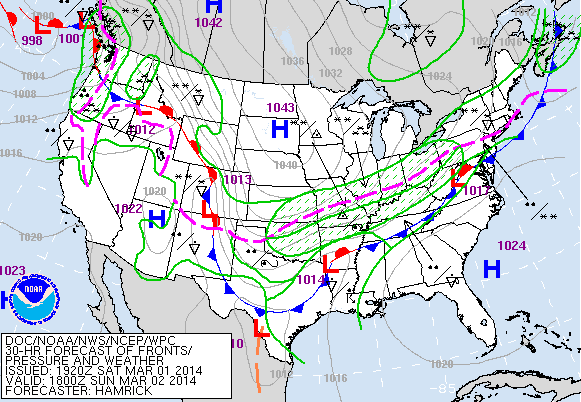
Low pressure moving eastward through Quebec will drag a cold front across the Northeast and the Ohio Valley tonight that will become nearly stationary. Very cold Arctic air is in place across the Northern Plains and the Great Lakes which will gradually push southeastward over the next two days. Lows tonight in northern Minnesota and North Dakota will plunge down to 30 to 35 below zero with wind chills down to 50 to 60 below zero. International Falls, MN is forecasting a low of 39 below zero tonight with wind chills as low as 55 below zero. Low pressure over the southern Rockies will develop and move along the front spread snow, sleet, freezing rain and rain as it moves across the Tennessee River Valley and the Mid-Atlantic states. Three to 6 inches of snow can be expected for the New York City area with the heaviest snowfall up to a foot across northern Delaware and southern New Jersey. As much as 10 to 14 inches of snow is forecast in Dover, DE and Atlantic City, NJ. One to 3 inches of snow and ice is forecast for Baltimore, a coating of ice in Washington, D.C. and up to 10 inches in Philadelphia. Very cold air with near record low temperatures will follow the snow Monday night and Tuesday morning with lows in the single digits in the New York City metro area.
From the Green Bay, NWS:
The average temperature for the winter in Green Bay was 10.6 degrees or 8.8 degrees below
normal. The winter of 2013-14 will go down in the record books as the 2nd
coldest winter on record. Records date back to 1886.
From the Minneapolis, NWS:
Eau Claire ties its coldest winter on record, while St. Cloud
finishes in the top five, and the Twin Cities in the top ten. Meteorological winter is from December through February.
George Wright is a Certified Consulting Meteorologist for Wright Weather Consulting, LLC. Visit our website at WrightWeather.com. Follow George Wright on Twitter @gwweather.


