Search This Blog

Monday, January 31, 2011

ANOTHER MAJOR Winter Storm for the New York City Metro Region


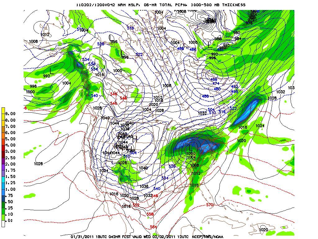
A very strong storm will form over the Southern Plains in the next 24 hours that will produce a major blizzard from Oklahoma to the Great Lakes and eastward across the Ohio Valley on Wednesday. Heavy rain and thunderstorms will result in flooding in parts of the Tennessee River Valley and the Gulf Coast. Snow, sleet and freezing rain will occur on Tuesday here in the NYC metro area with up to 12" in the far northern and western suburbs to 3 to 5 inches here in Manhattan. Lower amounts of snow and sleet will accumulate near the coast especially across eastern Long Island. A strong southern jet stream combined with bitterly cold Arctic high pressure moving southward across the Rockies will result in snow and sleet with very cold readings down to 10 degrees on Tuesday night in northern Texas including Dallas but temperatures will warm up in time for Super Bowl Sunday at Texas Stadium. The mixed precipitation will change to all rain as warm air advection aloft with temperatures rising to above freezing at the surface. This is a major ice storm for the Northeast that could bring down many trees and powers. More on this storm tomorrow.


George Wright is a Certified Consulting Meteorologist for Wright Weather Consulting, Inc. Our website is WrightWeather.com. George is also a meteorologist with Cablevision News 12.

Saturday, January 29, 2011

Another Winter Storm on the Way For This Tuesday and Wednesday in the Northeast...

Latest model guidance continues to indicate that another winter storm will impact the Northeast including New York City, Philadelphia and Boston on Tuesday and Wednesday. Depending on the track of the storm, it appears that this storm will produce snow on Tuesday and then snow, sleet, freezing rain and rain on Wednesday. More on this storm later this week.


George Wright is a Certified Consulting Meteorologist for Wright Weather Consulting, Inc. Our website is WrightWeather.com. George is also a meteorologist with Cablevision News 12.

Light Snow Likely Today Across NJ, CT and NYC


A fast moving area of low pressure will generate light snow this afternoon here in the NYC metro area.  More cold weather will follow in the wake of the storm.  There could be up to an inch in parts of the area.  Look for another storm this Wednesday and Thursday.  

George Wright is a Certified Consulting Meteorologist for Wright Weather Consulting, Inc. Our website is WrightWeather.com. George is also a meteorologist with Cablevision News 12.

Thursday, January 27, 2011

Record Snowfall This January in NYC Metro Area...

This January is the snowiest on record in Central Park (36"), Newark, (37.3"), Bridgeport (41.8"), La Guardia (32.4") and Islip (34.2").


George Wright is a Certified Consulting Meteorologist for Wright Weather Consulting, Inc. Our website is WrightWeather.com. George is also a meteorologist with Cablevision News 12.

Heavy Snow Tonight Across the New York City Metro Area...


Snow continues to fall heavily here in Midtown at 12:50 A.M. The snow began as sleet and then it changed to heavy snow by 7:15 p.m. There is about 8-9 inches of snow so far on the ground in Manhattan. Between 3.5 and 4.0 inches fell through 1 PM today and then a heavier area of snow fell this evening and early in the morning. The roads are snow covered and the trees are covered in the heavy, wet snow that is sticking to all the branches. The radar shows heavy bands of snow across northern Monmouth County as well as NYC, Long Island and especially CT. The snow will end by 6 AM or so and it will be sunny later in the day on Thursday.

George Wright is a Certified Consulting Meteorologist for Wright Weather Consulting, Inc. Our website is WrightWeather.com. George is also a meteorologist with Cablevision News 12.

Wednesday, January 26, 2011

Winter Storm Warning through Thursday Morning for NYC Metro Area...8 to 12" Expected


An area of snow this morning has produced 2 to 3 inches of snow across the NYC metro area including NJ and CT. Light snow continues in the city now. Heavier snow is expected tonight with a Winter Storm Warning in effect through Thursday morning. The storm is near Cape Hatteras and it will quickly track northeast spreading snow to our region. More on this storm later today.


George Wright is a Certified Consulting Meteorologist for Wright Weather Consulting, Inc. Our website is WrightWeather.com. George is also a meteorologist with Cablevision News 12.

Tuesday, January 25, 2011

Light Snow Today...1 to 3" Possible In and Around New York City


A low pressure trough and weak upper level vorticity advection is generating a heavier than expected snowfall across the NYC metro area this morning. Only light snow and snow showers were expected but it appears accumulations of 1 to 3 inches will occur.


George Wright is a Certified Consulting Meteorologist for Wright Weather Consulting, Inc. Our website is WrightWeather.com. George is also a meteorologist with Cablevision News 12.