skip to main |
skip to sidebar
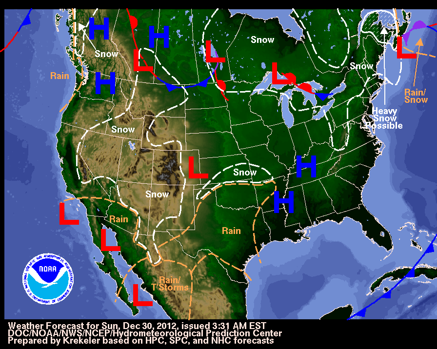
After a stormy, active pattern the last few weeks it will be mostly dry and seasonable across the nation today. A ridge of high pressure is located along the west coast at 500 mb and this will keep it dry along the west coast for much of the week. A trough at 500 mb across the Southwest will track eastward producing a few showers and a few thunderstorms across Texas and the southern Plains tomorrow. To the north of this area of moisture, the air will be cold enough to produce light snow across Colorado, Missouri and Oklahoma. This area of precipitation shifts eastward on Tuesday with a relatively large area of showers and thunderstorms across the Mississippi River Valley and light snow across the Ohio and Tennessee River Valleys. This area of moisture moves almost due east in the Southeast by Thursday. A disturbance will generate showers and thunderstorms along the eastern Gulf Coast and Florida on Friday. In the Pacific Northwest, the weather remains dry through Wednesday with a relatively weak storm producing light rain and snow on Thursday. By Sunday, nearly the entire nation is forecast by the GFS to be dry with hardly any precipitation forecast except for flurries in the Great Lakes and a few showers in Florida. The weather pattern is forecast to become more active after this Sunday but no major Arctic outbreaks are forecast. Have a great New Year in 2013. The GFS is forecasting that the NAO will turn positive during the first week of the new year and then trend negative again afterward.
George Wright is a Certified Consulting Meteorologist for Wright Weather Consulting, LLC. George is also a meteorologist with ABC News and Cablevision News 12. Our website is WrightWeather.com. Follow George on Twitter.
A storm will pass to the south and east of New York and Long Island on Saturday evening. This storm will produce 2 to 4 inches of snow beginning Saturday morning and ending by midnight Saturday night.
George Wright is a Certified Consulting Meteorologist for Wright Weather Consulting, LLC. George is also a meteorologist with ABC News and Cablevision News 12. Our website is WrightWeather.com.
An strong area of low pressure will track northeastward into the Northeast this afternoon and tonight. The low is forecast to move over New York City by Thursday morning. A High Wind Warning is now effect for the entire New York City metropolitan area through early Thursday morning with gusts up to 60 mph possible. A Winter Weather Advisory and Winter Storm Warning are posted for the northern and western suburbs of New York City for 2 to 6 inches of snow, sleet and freezing rain that could lead to downed trees and power lines. As much as 1 to 2 inches of rain is forecast for the city and along the coast. The storm will move away by Thursday afternoon into New England.
There is a chance of light snow Saturday and Saturday night and again around next Wednesday for the New York City metropolitan area and the latest forecast models indicate that the weather will be seasonably cold for the next 1 to 2 weeks. Stormy conditions with more heavy snow in the mountains will continue today for the Pacific Northwest. The trend for this area is for the frequent storms to continue to move into the area. The NAO is forecast to trend to a positive phase in the next two weeks according to the GFS model and this normally means that there will be milder weather and less snow for the Northeast. Let's see if this verifies in the next several days.
George Wright is a Certified Consulting Meteorologist for Wright Weather Consulting, LLC. George is also a meteorologist with ABC News and Cablevision News 12. Our website is WrightWeather.com.