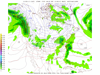
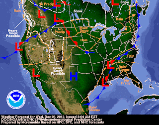
The GFS model and the current upper-level flow at 500 MB continue to indicate that a polar vortex over north central Canada will influence the weather across the lower 48 states for the next week to ten days. This vortex is forecast to lift northwestward into Alaska 300 hours out by Monday, December 17th. A ridge is prevalent over the eastern Pacific with another blocking ridge over the western Atlantic near Greenland during this period. A shortwave trough generates a Midwest snowstorm this weekend with overrunning snows falling from the southern Great Lakes to the southern Rockies including the states of Colorado, Nebraska and Kansas. The storm strengthens and tracks rapidly northeastward into the St. Lawrence River Valley on Monday/Tuesday (December 17th-18th) spreading rain and snow to the Great Lakes and the Northeast. As the vortex over central Canada begins to lift northwestward by December 17th, a shortwave rotating around this vortex generates another surface low near the upper Midwest by Tuesday, December 11th and this storm intensities and tracks east-northeastward across the Great Lakes into eastern Canada by Friday/Saturday, December 15th-16th. This storm will also generate rain and snow to the Great Lakes and the Northeast on Friday/Saturday, December 14th-15th. A fairly large and strong high pressure system decends from western Canda as this storm tracks eastward bring a shot of cold but seasonable air across the upper Midwest and eastward across New England. A shortwave is forecast to begin diving southward from British Columbia on Friday, December 14th. This shortwave then broadens latitudinally as it moves across the Midwest and then phases in with an upper-low that is generated by vorticity circulating around the upper low that is forecast to track into Alaska. A storm system then is forecast to form (in a much farther southerly location than previous storms so far this month) near the Gulf Coast. A large area of light to moderate rain is forecast to extend from the Great Lakes to the Gulf Coast on Monday, December 17th. The surface low than tracks northeastward off the North Carolina coast and south of New York City on Monday night and Tuesday spreading rain, sleet and snow to the area. In the wake of this storm, a ridge with fair weather builds in across the Northeast for the next few days through Friday, December 21st. On this day, at 384 hours, a large storm is moving into the Pacific Northwest and an area of rain is forming along the Gulf Coast. The northern half of the lower 48 states is seasonably cold at this time with no large outbreaks/high pressure centers indicated to be moving southward from Canada.
The North Atlantic Oscillation (NAO) index has been running negative for most of this fall with a positive trend the last few days. The latest GFS two week forecast is for a change back to the negative NAO trend.
George Wright is a Certified Consulting Meteorologist for Wright Weather Consulting, LLC. George is also a meteorologist with ABC News and Cablevision News 12. Our website is WrightWeather.com. Follow George Wright on Twitter.


