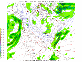
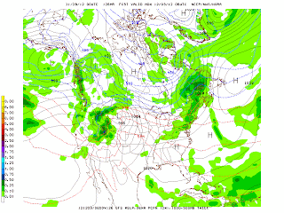
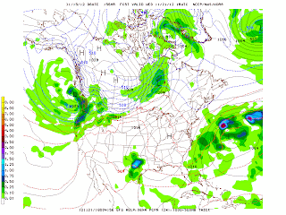
Light snow and rain fell across the Northeast today with up to 6 inches of snow in the suburbs of New York City. In the city, the precipitation fell as a mix of mostly rain with some snow. There was no accumulation in the city. Some snowfall totals included:
6.0" West Milford, NJ
4.0" Greenville, NY
3.6" Ringwood, NJ
3.4" Cedar Grove, NJ
2.8" Armonk, NY
1.4" Elizabeth, NJ
1.2" Westfield, NJ
0.4" Newark, NJ
The GFS model had been forecasting a rain/snow event as early as November 15, 2012 in its 384 forecast a more intense storm was forecast to impact the Northeast and Mid-Atlantic States but as early as November 20, 2012, the model weakened the storm with much less upper air support. Excellent work by the GFS model and NOAA NCEP. Numerical weather prediction was one of the greatest inventions of the 20th century and was first proposed and studied by the great L.F. Richardson in 1922.
George Wright is a Certified Consulting Meteorologist for Wright Weather Consulting, LLC. George is also a meteorologist with ABC News and Cablevision News 12. Our website is WrightWeather.com.
Wednesday, November 28, 2012
Saturday, November 24, 2012
Cold Air Now Pouring into the Northeast, Lake Effect Snows in Upstate New York...
A strong cold front ended our mild Thanksgiving week weather last night and early this morning. Showers preceded the front and now strong cold air adection has moved in across the Great Lakes and the Northeast. Lake effect snows are falling in upstate New York - the first significant lake effect snowfall of the season. The GFS continues to develop a relatively weak low pressure system that tracks close to the NYC metro area on Wednesday, November 28th. The model has been consistent with this system and has been forecasting a rain/snow event on this day for over a week. A shot of very cold air will move in behind the low on Thursday and into next weekend across the Northeast. Another storm moves into northern California and the Pacific Northwest on Tuesday and Wednesday. A very strong ridge is forecast to develop over eastern Canada and the eastern US by December 3rd and 4th. This will mean a mild start to December in the eastern third of the nation. A strong area of low pressure will track across the Great Lakes around this time dragging a cold front across the Northeast with showers and then a turn to more seasonable weather by December 7th and 8th. After this date, the trend appears to be a colder one with a storm moving into the Pacific Northwest, a low tracking across eastern Canada and low pressure begining to organize in the Gulf Coast region.
The North Atlantic Oscillation (NAO) is forecast to continue its strong negative trend over the next two weeks.
George Wright is a Certified Consulting Meteorologist for Wright Weather Consulting, LLC. George is also a meteorologist with ABC News and Cablevision News 12. Our website is WrightWeather.com.
Monday, November 19, 2012
GFS Model Trends and Forecast for the Next 2 Weeks...
The latest GFS model runs continue to indicate nice weather for Thanksgiving over most of the nation. A cold front will advect cold air from central Canada this Saturday and Sunday. A 1000 mb - 500 mb thickness of 518 dm is forecast for NYC on Sunday at 12 Z. Light snow can be expected in the Great Lakes with lake effect snowfall possible. There could also be a few flurries in the NYC metro area. For the past week, the GFS has been forecasting that a storm will form near the Ohio Valley and then move northeast. The model has been forecasting different tracks for the resultant low that forms. In the latest run, the storm tracks into eastern Ontario spreading a large area of rain and snow to the Northeast on the 28th and 29th. Rain changing to snow would be expected in the NYC metro area under the current scenario. In the wake of this storm, the coldest air of the season will plunge across the Great Lakes and the Northeast with lake effect snows in upstate New York. A thickness of 514 dm is forecast for the NYC metro area on Saturday, Dec. 1st at 6 Z. The first day of December will really feel like winter according to the current model run. The first few days of December is forecast to be seasonably cold with a zonal flow at 500 mb over the eastern half of the country. A storm system is forecast to spread rain with snow at the higher elevations along the west coast and then down to California. As always, this long range forecast will likely change in the next few days.
George Wright is a Certified Consulting Meteorologist for Wright Weather Consulting, LLC. George is also a meteorologist with ABC News and Cablevision News 12. Our website is WrightWeather.com.
George Wright is a Certified Consulting Meteorologist for Wright Weather Consulting, LLC. George is also a meteorologist with ABC News and Cablevision News 12. Our website is WrightWeather.com.
Thursday, November 15, 2012
Trends for the Next 16 Days...
The North Atlantic Oscillation Index (NOA) has been running negative since mid-September. The index has turned positive in the past 6 days. The latest 14 day GFS model forecasting indicates that the index is predicted to become negative by this weekend and for the next week to 10 days thereafter. A coastal storm that had been forecast last week for early next week is now forecast to remain weak and move south abd east of the New York City metro area. No jet stream phasing is forecast to occur and the upper-air support remains weak with a broad trough reflected at 500 MB through the weekend. An area of low pressure near Florida now will produce some light rain across the Southeast and will then move northeast through Sunday. Some light rain may fall across coastal sections of the Carolinas this weekend and in the New York City metro area on Monday. High pressure builds in across the Northeast over the next few days producing dry weather through Sunday here in New York. A storm produces rain and snow in the Pacific Northwest this weekend. A series of storms will then move in from the Pacific and will impact this region through most of next week. The long range GFS model is indicating that the coldest air mass of the season will plunge down from Canada into the northern Rockies by next Friday. Strong low pressure will form and track across the Great Lakes producing showers in the Northeast next Sunday with cold air advecting behind the front. Then another storm forms in the Gulf of Mexico and moves northeastward producing snow and rain to the Northeast on Wednesday, November 28th. This forecast will change over the next several days, however, what is important is to look at the overall trend the GFS is forecasting which is stormy conditions in the Pacific Northwest and the coldest air of the season possibly moving into the lower 48 states by the 26th.
George Wright is a Certified Consulting Meteorologist for Wright Weather Consulting, LLC. George is also a meteorologist with ABC News and Cablevision News 12. Our website is WrightWeather.com.
George Wright is a Certified Consulting Meteorologist for Wright Weather Consulting, LLC. George is also a meteorologist with ABC News and Cablevision News 12. Our website is WrightWeather.com.
Subscribe to:
Comments (Atom)


