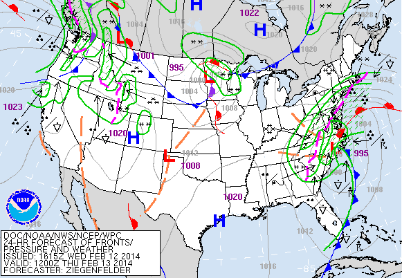
More than 200,000 people are without power this afternoon in Georgia and this number continues to climb. Over 2,000 flights have been cancelled at the Atlanta airport. This is the worst ice storm in a decade for the area with over 8 inches of snow expected in western portions of South Carolina. The ice and snow began around 4 AM this morning. Atlanta is reporting freezing rain with a temperature of 28 degrees at this present time. Winter Storm Warnings, Watches and Advisories are in effect from eastern Arkansas, across northern Louisiana, Virginia into the Northeast. An additional 3 inches of snow and 1/4 to 2/3 of an inch of ice is expected in Atlanta through tonight. The heaviest icing is expected to the southeast of Atlanta in Washington, GA and Eatontown, GA. Up to 10 inches of snow is forecast in the mountains of northern Georgia. Temperatures will climb into the 50s to near 60 later in the week.
From the The Atlanta Journal-Constitution:
By Mike Morris
Don’t be fooled by the lunchtime lull in the freezing rain and snow that has cut power to more than 225,000 Georgians. There’s more of the wintry mix to come, and temperatures that dropped below freezing before daybreak won’t climb back above 32 degrees until Thursday afternoon.
Channel 2 meteorologist David Chandley likened the winter storm to a football game, saying late Wednesday morning that it’s “still not halftime yet by any means. We do have a break in the precipitation, but we’ve got a lot more to go through.”
“It’s a bit quiet right now, but it’s going to get a lot noisier later this afternoon and overnight,” Chandley said just before noon.
Fears of widespread power outages came to fruition as the ice and snow storm that forecasters have been warning about for days pounded metro Atlanta and the northern half of the state.
More than 168,000 Georgia Power customers had lost electricity by 1 p.m., with service already being restored to some 48,000 of those customers.
An additional 60,000 customers of the state’s electric membership cooperatives had also lost power by early afternoon, as ice-laden trees and powerlines came crashing down.
In northeast Atlanta, a tree crashed through the roof of a house on Martha Avenue around 5 a.m., injuring an 88-year-old woman who lived there with her grandson. The woman was taken to Grady Memorial Hospital for treatment of a gash over her eye.
The ice started accumulating on metro Atlanta roadways around 4 a.m., and by 6:30, the interstates were “awful all over town,” according to Mark Arum in the AM750 and 95.5FM News/Talk WSB Traffic Center.
“All of the interstates, all of the secondary routes, all of the surface streets, are all iced over,” Arum said. “Where you are right now is where you’re going to be tomorrow morning, there’s no doubt about it.”
It’s being called catastrophic and historic, and those aren’t words tossed around lightly, according to meteorologist Brad Nitz with Channel 2 Action News.
Temperatures at 11 a.m. included 28 degres in Chamblee, 29 in Marietta and 30 at Hartsfield-Jackson International Airport.
Those temperatures are expected to remain below the freezing mark until sometime Thursday afternoon, with all of metro Atlanta under either a winter storm or ice storm warning, forecasters said.
Here’s what you need to know as the ice and snow continues to build on roads, trees and power lines:
The roads: “Folks need to be aware, it is going to be treacherous,” said Mark McKinnon, a spokesman for the Georgia Department of Transportation. “If you don’t have to be on the roads, it’s a good idea to stay home.”
GDOT Commissioner Keith Golden was even more emphatic: ““This is a very dangerous ice storm and we strongly encourage the public to stay off the roads unless it is an extreme emergency.”
With icy conditions worsening around the state, GDOT officials said they may have to consider trying to keep just one, rather than two righthand interstate lanes in metro Atlanta passable for motorists on Wednesday as they originally planned.
The reason is that the situation in Augusta is extremely perilous and of 12 trucks that had been borrowed from that area, four are being sent back.
GDOT deputy director Todd Long said, “Augusta is getting hammered.”
Those four trucks are needed to escort emergency workers, aid providers and power companies deploying to Augusta, said Dale Brantley, state maintenance engineer for GDOT.
“If we start losing resources, we may have to drop from two to one lane (of treating interstates),” Brantley said. “We are not there yet.”
Road crews began treating and retreating interstates at 9 p.m.
Tuesday. By 4 a.m., the first reports of icy spots were beginning to filter in from places like Cherokee and Hall counties.
By 9 a.m., GDOT was reporting that roads south of Atlanta in Henry, Butts and Lamar counties were also becoming icy.
The good news is, motorists appear to be heeding the warnings with very few cars on most metro interstates.
The forecast: The threat is actually three-pronged, with heavy snow expected throughout the day from the northern suburbs northward and mainly ice south and east of Atlanta, where the ice storm warning is in place. Compounding problems will be winds building to 20 to 25 mph, with higher gusts.
George Wright is a Certified Consulting Meteorologist for Wright Weather Consulting, LLC. Visit our website at WrightWeather.com. Follow George Wright on Twitter @gwweather.