Search This Blog

Thursday, December 31, 2009

New Years Eve Snowfall in NYC...Happy New Years


The weak storm and overunning precipitation produced 1 to 2 inches of snow in the NYC metro area this morning, New Years Eve through noon. At around 10:30 a.m. larger flakes began to mix in with the smaller flakes that were falling. The temperature at this time was 31 to 32 degrees. Later in the morning, the precipitation changed to rain and it was cloudy with temperature in the mid 30s during the afternoon with a little light drizzle. Upper-level weak disturbances will create the chance for snow showers tonight and Friday with that upper closed low generating areas of positive vorticity advection and rising motion that will generate scattered flurries and snow showers especially over hilly terrain inland. All models keep the second and stronger storm well to our south and east and strong cold air advection with wind gusts to over 40 mph can be expected this weekend. Have a great New Years.

George Wright is a Certified Consulting Meteorologist and President of Wright Weather Consulting, Inc. George is also a meteorologist with News 12. Our website is WrightWeather.com.

Snow to Rain on New Years Eve...


A weak storm system will pass to the southeast of NYC on Thursday, New Years Eve. Wet snow will change to rain by afternoon and the rain will continue into the evening with temperatures above freezing. The radar indicates the extent of the precipitation at 2 AM on December 31, 2009. The NAM forecasts for 42 hours indicate that the 850 mb 32 degree contour will be to the north and west of NYC across northern NJ which will allow for mostly rain to the south and east of this line. The second and stronger storm that forms off the southeast coast of the US is kicked well out to see by the developed closed low at 500 mb over the Northeast after 42 hours. As expected earlier this week, the storm would be weaker and will not result in much snowfall and will produce mostly rain along the coast, in the city and Long Island. Have a great New Years.

George Wright is a Certified Consulting Meteorologist and President of Wright Weather Consulting, Inc. Our website is WrightWeather.com.

Wednesday, December 30, 2009

Weaker Trend Continues for This Week's Storm in NYC Area...

As indicated in my earlier posts, the models continued to weaken the weather system (see NAM and GFS output above for Friday at 1 PM or the 66 hour forecast) that is forecast to bring rain and snow to the NYC metro area on Thursday and Friday (New Years Eve and New Years Day 2010). The forecast is now for little upper-air support and phasing in of the northern and southern branches of the jet stream or positive vorticity advection/upper level divergence when the storm is over eastern Carolina. The storm does intensify when it moves into eastern New England with significant snows in Maine and coastal New Hampshire and Massachusetts. All models including the European runs indicate another blast of cold air for early next week. The models are trending for a seasonably cold or below normal start to the new year. The cold air will extend across the upper Midwest, the Great Lakes, the Northeast and Mid-Atlantic states.

The GFS is forecasting a major cold air mass that will penetrate the deep south on January 5, 2010 through January 8, 2010 resulting in at or below freezing temperatures across the Gulf Coast as well as central and northern Florida. The Northeast during this period and beyond remains cold and relatively dry. No major storms are forecast for the NYC area by the GFS through January 11, 2010.

George Wright is a Certified Consulting Meteorologist and President of Wright Weather Consulting. Our website is WrightWeather.com.

Tuesday, December 29, 2009

Interesting Cutoff Low Pattern Forecast at 500 mb

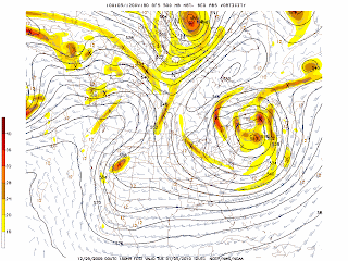
The GFS continues to develop a cutoff low after the weak coastal storm moves to the northeast of the NYC area. The graphics above indicate that lobes of vorticity may generate some clouds and snow or rain showers but no major storm is expected. The low begins to form on January 2, 2010 (after 108 hours) and then moves away to the northeast by January 5, 2010.

George Wright is a Certified Consulting Meteorologist and President of Wright Weather Consulting, Inc. Our website is WrightWeather.com.

Weaker Storm Forecast by NAM and GFS for NYC Area


The model graphics for 84 hours at Friday at 7 AM (New Years Day morning) indicate that the storm is forecast to be weaker and warmer than the storm of December 19-20, 2009 as I indicated in earlier posts. The storm appears to strengthen but only after it has moved into coastal New England. With ocean temperatures in the upper 40s in the NYC area, a flow off the ocean from the east or southeast will result in temperatures above freezing and a change to sleet and then to rain along the coast, NYC and Long Island. Snow, sleet and freezing rain can be expected inland but no major accumulations are expected at this time. Another blast of cold air will move into behind the storm for the first week of 2010.

George Wright is a Certified Consulting Meteorologist and President of Wright Weather Consulting, Inc. George is also a meteorologist with Cablevision's News 12. Our website is WrightWeather.com.

Sunday, December 27, 2009

Potential NYC Area Snowstorm for Friday?


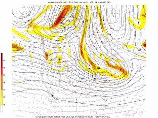
Models forecast potential snowstorm for NYC metro area (one day earlier now) for Friday, January 1, 2010. The last two maps above are the 84 hr. forecast for Wednesday at 7 PM from the NAM model. The model is forecasting developing rain and thunderstorms along the Gulf coast in response to a moist southerly jetstream flow and upper trough that is moving across the Midwest at 500 mb. The trough axis at 500 mb extends approximately from Nebraska through Texas. This energy generates a weak coastal low that spreads rain and some snow to the north across the Southeast and Mid-Atlantic states. However, most importantly, there is strong jetstream energy injecting through the Southwest US and this develops a coastal storm off the Mid-Atlantic coast that tracks northeast just to the south and east of NYC and Long Island. Another vigorous shortwave trough over western Canada also moves to the southeast and phases in with the southern trough producing a large cyclonic vortex over the Northeast and Ohio Valley by Saturday. This will result in snow showers in the Tri-State area after the storm has moved into eastern New England. This storm is similar to the one that occurred on December 19-20, 2009 in that it follows a similar track. The GFS model runs are provided in the first three maps above for the surface, 500 mb and 850 mb levels. The upper air support differs and this creates the main difference between these two storms: the 850 mb low passes closer to NYC and the 32 F 850 mb temperature isotherm is forecast to be farther west setting up over NYC, northern NJ and southeast CT. This would result in a mix of snow, sleet and freezing rain with a potential changeover to rain along the Jersey Shore and Long Island later in the morning and into the afternoon on Friday. Before any mixing, there will be some accumulation of snow. Of course the pattern could change on future model runs.
Right now, the models are indicating that this storm will move quickly, will be weaker, may not produce all snow and it will not produce anything close to the 2 ft. + snowfalls that occurred in eastern Long Island, southern NJ, MD and southeast PA on December 19-20, 2009. Future model runs could change drastically in the next couple of days. The UKMET keeps the coastal storm well off the coast and out to sea by Friday, January 1, 2010 but the European model forecasts a coastal storm. All models agree that behind this storm, very cold Arctic air will plunge down producing very cold weather for the first weekend of 2010 for the upper Midwest, the Great Lakes, the Ohio Valley, the Northeast and Mid-Atlantic States.

George Wright is a Certified Consulting Meteorologist and President of Wright Weather Consulting, Inc. Our website is WrightWeather.com.

Rain Ending in the Northeast...Partial Sunshine for Sunday

The storm that produced heavy snow and blizzard conditions in the Midwest is finally moving to the northeast. The upper level energy from this storm will produce showers and snow showers in the Northeast on Monday. This shortwave energy will also usher in Arctic air that will be in the Northeast for most of this week. The combination of rain and snowmelt have produced flooding of roadways as well as small streams. The storm and rain will move away Sunday morning and we'll see clearing in the afternoon. Rain and snow showers are forecast with an Arctic front that will pass the area on Monday and Tuesday's highs will only in the 20s.

George Wright is a Certified Consulting Meteorologist and President of Wright Weather Consulting, Inc. Our website is WrightWeather.com.

Saturday, December 26, 2009

Early GFS Model Runs Forecasting a Snowstorm for NYC Area Next Week...


The latest 168 hour forecast from the GFS weather forecasting model is predicting a significant snowstorm for the Mid-Atlantic and coastal Northeast states for January 1-3, 2010. It is still quite early and many things can change but this will be interesting to watch later this week.

George Wright is a Certified Consulting Meteorologist and President of Wright Weather Consulting, Inc. Our website is WrightWeather.com.


Heavy Rain and Strong Winds in the Northeast...

The intense cyclonic vortex in the upper levels of the atmosphere that was responsible for the Midwest blizzard that dumped 39 inches of snow in Lead, SD continues to produce rain the in Northeast. Flood Advisories and Flood Warnings have been issued for interior northern and central New Jersey, eastern Long Island and southeast Connecticut. The combination of rain and snowmelt have produced flooding of roadways as well as small streams. The storm and rain will move away Sunday morning and we'll see clearing in the afternoon. Rain and snow showers are forecast with an Arctic front that will pass the area on Monday and MUCH colder air will move in for Tuesday with highs only in the 20s.

George Wright is a Certified Consulting Meteorologist and President of Wright Weather Consulting, Inc. Our website is WrightWeather.com.
Friday, December 25, 2009

Midwest Blizzard Pounds Iowa, the Dakotas, Minnesota and Nebraska


A very strong storm swirling near Iowa continues to dump heavy snow with blizzard conditions in the Dakotas, Iowa, Minnesota and Nebraska. As much as 15 to 20 inches of snow is forecast with Blizzard Warnings in effect for these states. Winds will gust to 40 to 50 mph creating drifting and blowing snow. This storm will track northeast into Canada and will not directly affect the NYC area. We will see rain from a portion of this system Christmas night and on Saturday.

George Wright is a Certified Consulting Meteorologist and President of Wright Weather Consulting, Inc. Our website is WrightWeather.com.
Midwest Christmas Blizzard...

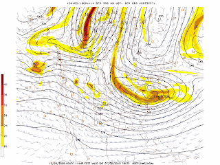
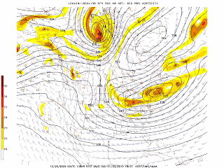
The storm that brought snow to Texas (giving Dallas its first white Christmas since 1920) and tornadoes to the Gulf coast is now producing a blizzard in the upper Midwest for Christmas Day. Up to 20 inches of snow is forecast. This storm will produce rain in the NYC area Christmas night and on Saturday. Behind the storm, very cold air will again invade the upper Midwest and the Northeast. The maps above are the 18 hour NAM forecasts for the surface and 500 mb levels. A huge upper-level low can be see circulating in the Midwest at 500 mb (approximately 18,000 ft.)

George Wright is a Certified Consulting Meteorologist and President of Wright Weather Consulting, Inc. Our website is WrightWeather.com.
Tuesday, December 22, 2009

Christmas Day Forecast 2009


The NAM continues to slow down the onset of the precipitation for the NYC metro area. A big ridge of high pressure and thermal ridge develops that will keep the precipitation as mostly rain across the entire region with perhaps some sleet or wet snow to the north and west of the city. However, there will be plenty of snow left on the ground from last weekend's storm for a white Christmas.

George Wright is a Certified Consulting Meteorologist and President of Wright Weather Consulting, Inc. George is also a meteorologist with Cablevision's News 12. Our website is WrightWeather.com

Sunday, December 20, 2009

Final Snowfall Totals for December 19-20, 2009 Storm

The heaviest snow fell across southeast CT and eastern Long Island. The snow will stick around through much of this week with cold temperatures. There is a chance for snow or sleet and rain on Christmas day.

The final snowfall amounts received by the National Weather Service:

CONNECTICUT

...FAIRFIELD COUNTY...
DARIEN 11.5 1200 PM 12/20
NEW CANAAN 10.3 1200 PM 12/20
BRIDGEPORT 9.0 700 AM 12/20
DANBURY 7.0 1200 PM 12/20

...MIDDLESEX COUNTY...
CLINTON 20.0 900 AM 12/20
EAST HADDAM 20.0 1200 PM 12/20
OLD SAYBROOK 20.0 1200 PM 12/20
HADDAM 14.0 600 AM 12/20
MIDDLETOWN 12.0 830 AM 12/20

...NEW HAVEN COUNTY...
NORTH BRANFORD 12.0 830 AM 12/20
NEW HAVEN 11.0 1200 PM 12/20
MILFORD 10.0 1200 PM 12/20
NEW HAVEN COUNTY 8.5 400 AM 12/20
NORTH HAVEN 8.5 830 AM 12/20
BEACON FALLS 7.5 600 AM 12/20
WATERBURY 6.3 1200 PM 12/20

...NEW LONDON COUNTY...
NORWICH 20.0 1200 PM 12/20
OLD LYME 20.0 940 AM 12/20
MONTVILLE 19.0 900 AM 12/20
GROTON 18.0 1200 PM 12/20
NORTH FRANKLIN 15.0 850 AM 12/20
GROTON LONG POINT 13.0 500 AM 12/20
NEW LONDON 12.0 605 AM 12/20
LISBON 11.0 334 AM 12/20

NEW JERSEY

...BERGEN COUNTY...
PARAMUS 9.5 515 AM 12/20
BERGENFIELD 8.2 900 AM 12/20
RUTHERFORD 8.0 515 AM 12/20
GARFIELD 7.5 1100 AM 12/20
MAHWAH 7.2 830 AM 12/20
FAIR LAWN 6.0 1002 AM 12/20

...ESSEX COUNTY...
NEWARK 11.2 1100 AM 12/20

...HUDSON COUNTY...
JERSEY CITY 10.0 515 AM 12/20
HARRISON 9.5 515 AM 12/20

...PASSAIC COUNTY...
CLIFTON 11.0 515 AM 12/20
RINGWOOD 10.0 515 AM 12/20
WAYNE 7.0 1201 PM 12/20

...UNION COUNTY...
ELIZABETH 11.0 515 AM 12/20
CLARK 10.0 515 AM 12/20
WESTFIELD 10.0 200 AM 12/20
PLAINFIELD 6.8 1201 PM 12/20

NEW YORK

...BRONX COUNTY...
BRONX 9.5 900 AM 12/20
EAST TREMONT 9.2 830 AM 12/20

...KINGS COUNTY...
SHEEPSHEAD BAY 13.2 430 AM 12/20
BROOKLYN 11.8 700 AM 12/20

...NASSAU COUNTY...
PLAINVIEW 15.2 900 AM 12/20
BETHPAGE 14.4 1000 AM 12/20
SEAFORD 14.0 959 AM 12/20
FLORAL PARK 13.5 600 AM 12/20
LIDO BEACH 13.5 900 AM 12/20
MINEOLA 13.4 959 AM 12/20
LYNBROOK 13.0 1100 AM 12/20
LONG BEACH 12.5 330 AM 12/20

...NEW YORK COUNTY...
NYC/CENTRAL PARK 10.9 700 AM 12/20
MANHATTAN 9.5 210 AM 12/20

...ORANGE COUNTY...
TUXEDO PARK 6.0 545 AM 12/20
WESTTOWN 3.8 830 AM 12/20

...QUEENS COUNTY...
NYC/JFK ARPT 14.2 700 AM 12/20
NYC/LA GUARDIA 8.8 700 AM 12/20

...ROCKLAND COUNTY...
NEW CITY 5.0 940 AM 12/20
STONY POINT 4.0 927 AM 12/20

...SUFFOLK COUNTY...
UPTON 26.3 156 PM 12/20
HOLTSVILLE 25.0 900 AM 12/20
BRIDGEHAMPTON 24.0 800 AM 12/20
MOUNT SINAI 24.0 945 AM 12/20
ISLIP 23.9 100 PM 12/20
SOUTHAMPTON 23.0 900 AM 12/20
CENTEREACH 21.0 1000 AM 12/20
RIVERHEAD 21.0 930 AM 12/20
RONKONKOMA 20.5 949 AM 12/20
SAG HARBOR 20.0 730 AM 12/20
SAYVILLE 19.8 700 AM 12/20
LINDENHURST 19.5 915 AM 12/20
PATCHOGUE 19.0 1047 AM 12/20
HOLBROOK 18.5 310 AM 12/20
COMMACK 18.2 500 AM 12/20
MEDFORD 18.0 330 AM 12/20
PORT JEFFERSON 18.0 900 AM 12/20
ROCKY POINT 18.0 157 PM 12/20

...WESTCHESTER COUNTY...
PORT CHESTER 11.5 915 AM 12/20
LARCHMONT 10.0 950 AM 12/20
HASTINGS-ON-HUDSON 9.0 600 AM 12/20
YONKERS 8.5 800 AM 12/20
WHITE PLAINS 7.0 1200 PM 12/20

George Wright is a Certified Consulting Meteorologist and President of Wright Weather Consulting, Inc. Our web site is WrightWeather.com.

Additional Snowfall Totals for the Snowstorm on December 19, 2009

These reports were received from the National Weather Service:

CONNECTICUT
DARIEN 6.5 1200 AM 12/20
BRIDGEPORT 6.0 1150 PM 12/19
GREENWICH 6.0 1215 AM 12/20
GREENWICH 6.0 145 AM 12/20
EASTON 5.0 1100 PM 12/19
MONROE 5.0 100 AM 12/20
DANBURY 2.5 125 AM 12/20
WESTBROOK 8.3 1215 AM 12/20
OLD SAYBROOK 6.0 1200 AM 12/20
HADDAM 3.5 1200 AM 12/20
NORTH BRANFORD 8.0 200 AM 12/20
MILFORD 7.3 1200 AM 12/20
NEW HAVEN 6.5 1200 AM 12/20
GROTON 8.0 1200 AM 12/20
LISBON 6.0 1233 AM 12/20
NORWICH 6.0 1200 AM 12/20

NEW JERSEY
GARFIELD 6.1 1115 PM 12/19
OAKLAND 5.5 1100 PM 12/19
RAMSEY 4.9 1000 PM 12/19
MAHWAH 4.3 926 PM 12/19
BERGENFIELD 4.2 1130 PM 12/19
MIDLAND PARK 4.0 900 PM 12/19
SADDLE BROOK 2.5 1000 PM 12/19
HASBROUCK HEIGHTS 2.4 1000 PM 12/19
PARAMUS 2.1 1000 PM 12/19
NEWARK 8.0 100 AM 12/20
MILLBURN 7.0 1130 PM 12/19
HARRISON 4.0 1000 PM 12/19
KEARNY 4.0 1000 PM 12/19
WEST MILFORD 8.0 1025 PM 12/19
HASKELL 6.5 1200 AM 12/20
CLIFTON 2.5 1000 PM 12/19
SCOTCH PLAINS 10.0 1048 PM 12/19
WESTFIELD 10.0 200 AM 12/20
ROSELLE 8.5 100 AM 12/20

NEW YORK
BROOKLYN MARINE PARK 11.5 100 AM 12/20
SHEEPSHEAD BAY 10.0 1130 PM 12/19
FLORAL PARK 11.8 250 AM 12/20
MASSAPEQUA 11.6 1150 AM 12/20
LIDO BEACH 11.5 1201 AM 12/20
ROCKVILLE CENTRE 10.8 1200 AM 12/20

NYC/CENTRAL PARK 9.9 100 AM 12/20
MANHATTAN 9.5 210 AM 12/20
NYC/JFK ARPT 10.9 100 AM 12/20
HOWARD BEACH 10.0 1200 AM 12/20
UPTON 21.0 310 AM 12/20
NORTH BABYLON 19.0 100 AM 12/20
ISLIP 17.1 300 AM 12/20
MOUNT SINAI 16.1 143 AM 12/20
ORIENT 15.0 200 AM 12/20
STONY BROOK 14.9 1235 AM 12/20
HUNTINGTON STATION 12.5 1145 AM 12/20
YONKERS 6.0 1100 PM 12/19
SCARSDALE 5.0 1110 PM 12/19

George Wright is a Certified Consulting Meteorologist and President of Wright Weather Consulting, Inc. Our web site is WrightWeather.com.

More Snowfall Totals for the Major Snowstorm on December 19, 2009

The following reports were received by the National Weather Service in Mount Holly, NJ:

DELAWARE
WILMINGTON 17.0 100 AM 12/20

MARYLAND
COLORA 17.2 1005 PM 12/19

NEW JERSEY
FOLSOM 20.0 126 AM 12/20
GALLOWAY 18.0 1045 PM 12/19
ATLANTIC CITY 11.6 100 AM 12/20
MEDFORD 24.0 1050 PM 12/19
SOUTHAMPTON 21.4 130 AM 12/20
TABERNACLE 21.0 1025 PM 12/19
WILLINGBORO 19.6 1100 PM 12/19
MOORESTOWN 17.0 1030 PM 12/19
DELRAN 15.0 1205 AM 12/20
ATCO 24.0 1100 PM 12/19
BLACKWOOD 22.0 1210 AM 12/20
SICKLERVILLE 22.0 1205 AM 12/20
ELDORA 14.0 1030 PM 12/19
DENNISVILLE 10.0 1030 PM 12/19
NEWPORT 24.0 200 AM 12/20
SWEDESBORO 22.0 1025 PM 12/19
FLEMINGTON 8.3 1025 PM 12/19
HAMILTON SQUARE 14.0 1045 PM 12/19
EWING 8.8 1205 AM 12/20
EAST BRUNSWICK 10.8 110 AM 12/20
HOPELAWN 10.2 1030 PM 12/20
NORTH BRUNSWICK 8.5 100 AM 12/20
EDISON 6.0 1110 PM 12/19
MILLTOWN 5.0 1033 PM 12/19
MILLTOWN 5.0 1030 PM 12/20
WOODBRIDGE 4.5 1033 PM 12/19
WOODBRIDGE 4.5 1030 PM 12/20
SOUTH PLAINFIELD 4.0 1045 PM 12/19
ISELIN 3.0 1045 PM 12/19
COLTS NECK 19.5 1050 PM 12/19
MANALAPAN 14.0 1205 AM 12/20
HOLMDEL 8.0 1033 PM 12/19
JACKSON 23.5 1045 PM 12/19
TOMS RIVER 21.0 1045 PM 12/19
BEACHWOOD 18.5 1205 AM 12/20
POINT PLEASANT BEACH 17.5 1000 PM 12/19
BROOKVILLE 16.0 1030 PM 12/19 OCEAN TWP
BRANCHBURG 10.0 1000 PM 12/19
NEWTON 4.0 1132 PM 12/19
SPARTA 3.9 1145 PM 12/19
HACKETTSTOWN 6.0 1155 PM 12/19
HOPE 4.5 1248 AM 12/20

PENNSYLVANIA
MAPLE GROVE 10.0 1140 PM 12/19
WEST CALN 19.3 1220 AM 12/20
WEST CHESTER 15.4 100 AM 12/20
WYNNEWOOD 16.5 1230 AM 12/20
KING OF PRUSSIA 14.2 1230 AM 12/20
PHILADELPHIA 22.9 100 AM 12/20 PHL INTL AIRPORT
PHILADELPHIA 14.8 1045 PM 12/19
PHILADELPHIA 11.5 230 AM 12/20

George Wright is a Certified Consulting Meteorologist and President of Wright Weather Consulting, Inc. Our web site is WrightWeather.com.

Snow Winding Down Across New Jersey


The latest Doppler radar indicates that heavy snow bands continue over eastern Long Island as a 2:45 AM. The precipitation is ending over western NJ with only light snow now falling over most of NJ. The watches and warnings are ending earlier as the precipitation moves away faster than expected.

The main reason the snow was not has heavy as expected in the NYC area was that the heaviest of precipitation remained to the south and east and the storm was not a slow mover. I mentioned this on Friday when the models were closing off the steering upper-air circulation but it continued to move eastward at a good pace. It turned out that it moved even faster than expected thereby reducing the accumulations. But still this was a major storm with heavy snowfall amounts in parts of the area.

George Wright is a Certified Consulting Meteorologist and President of Wright Weather Consulting, Inc. Our web site is WrightWeather.com.

Snow Ratio Confirmed for December 19, 2009


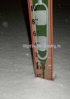
Snow typically has a 10:1 water ratio when the snow is collected in a gage and melted down. So if 10 inches of snow falls, this equals approximately one inch of precipitation (melted water equivalent). At colder temperatures the ratio of water equivalent to snowfall is higher. For the storm of December 19, 2009, I confirmed through measurement that the ratio was 15:1. The snow was light and easier to shovel since the snow contained less water since it fell at a colder temperature (cold air holds less moisture than warm air). This storm produced 10 inches in Perth Amboy, NJ (see gage measurement photo) with drifts up to 18 to 24 inches.


George Wright is a Certified Consulting Meteorologist and President of Wright Weather Consulting, Inc. Our web site is WrightWeather.com.

Snowfall Totals for the Major Snowstorm on December 19, 2009

The following snowfall totals for NJ, CT and NY were received by the National Weather Service:

CONNECTICUT

EASTON 5.0 1100 PM 12/19

GREENWICH 5.0 1115 PM 12/19
NORWALK 4.7 1057 PM 12/19
NEW CANAAN 4.5 1100 PM 12/19
DARIEN 3.5 1030 PM 12/19

SHELTON 3.1 1100 PM 12/19
NORTH HAVEN 2.1 1125 PM 12/19

NEW JERSEY

GARFIELD 6.1 1115 PM 12/19
OAKLAND 5.5 1100 PM 12/19
RAMSEY 4.9 1000 PM 12/19

MAHWAH 4.3 926 PM 12/19
MILLBURN 7.0 1130 PM 12/19
NEWARK 3.6 1005 PM 12/19
HARRISON 4.0 1000 PM 12/19
KEARNY 4.0 1000 PM 12/19

JERSEY CITY 3.5 1000 PM 12/19
SECAUCUS 3.5 1000 PM 12/19
WEST MILFORD 8.0 1025 PM 12/19
HAWTHORNE 5.5 1056 PM 12/19
WAYNE 5.5 1000 PM 12/19
SCOTCH PLAINS 10.0 1048 PM 12/19
UNION 5.0 1000 PM 12/19
CLARK 4.0 1030 PM 12/19
ELIZABETH 4.0 1000 PM 12/19

NEW YORK

SHEEPSHEAD BAY 7.0 1000 PM 12/19
BROOKLYN 5.2 1010 PM 12/19
LIDO BEACH 10.0 1100 PM 12/19
BELLMORE 9.8 1115 PM 12/19
LEVITTOWN 9.0 1105 PM 12/19
FLORAL PARK 8.2 1055 PM 12/19
BETHPAGE 6.6 1015 PM 12/19
NORTH MASSAPEQUA 6.6 1000 PM 12/19
SEAFORD 6.6 1000 PM 12/19
MERRICK 6.5 920 PM 12/19
BREEZY POINT 8.8 1011 PM 12/19
NYC/JFK ARPT 8.4 1030 PM 12/19
PATCHOGUE 11.6 1125 PM 12/19
UPTON 11.3 1132 PM 12/19
SOUTHAMPTON 10.7 1051 PM 12/19
YONKERS 6.0 1100 PM 12/19

George Wright is a Certified Consulting Meteorologist and President of Wright Weather Consulting, Inc. Our web site is WrightWeather.com.

9 Inches of Snow in Perth Amboy, NJ

Perth Amboy, NJ (Middlesex County) reported 9" of snow on the ground with drifts up to 18" at midnight. It was still snowing, 21 degrees and the wind was north to northeast at 5 to 15 mph. The strength of the wind has decreased with less blowing snow. The roads are snow covered and very slippery.

George Wright is a Certified Consulting Meteorologist and President of Wright Weather Consulting, Inc. Our web site is WrightWeather.com.

Saturday, December 19, 2009

Accumulating Snow Continues at 8 PM in NYC Area

The latest radar shows a large area of snow with the heaviest areas indicated by dark greek and yellow shading. The snow is circulating around an upper-level vortex that is forming over the Tri-State area. The storm is now intensifying off the the North Carolina coast and it will continue to drift away to the northeast. The snow will end by noon across the area from west to east.

George Wright is a Certified Consulting Meteorologist and President of Wright Weather Consulting, Inc. Our web site is WrightWeather.com.

Radar Shows a Huge Area of Precipitation...


Radar indicates bands of heavy snow with rates of 2 to 4 inches per hour now moving northward through Monmouth and Ocean Counties of NJ. Blinding snow, strong winds and temperatures in the 20s are occuring now throughout the region. As much as 12 to 16 inches of snow fell in the Washington, DC area and up to 25 to 30 inches of snow fell in parts of interior Virginia. Hundreds of flights have been cancelled, roads are snow covered and several people have died because of this storm.

George Wright is a Certified Consulting Meteorologist and President of Wright Weather Consulting, Inc. Our web site is WrightWeather.com.