skip to main |
skip to sidebar
Historic Winter Storm Possible for Eastern New England, Up to a Foot of Snow for NYC and Long Island
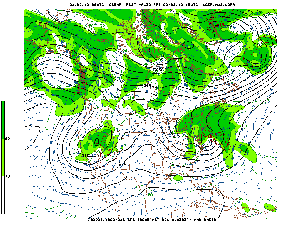
A Winter Storm Watch is in effect for the entire NYC metro area except a Blizzard Watch is in effect for the eastern 2/3 of CT and Suffolk County Long Island. The 06 Z or 2 AM GFS model runs indicate that cold air damming from the 1036 mb surface high along with a slightly more easterly storm track may keep New York City, northern NJ and at least the western half of Long Island at or below 32 F at the 850 mb level. This would indicate that a mix of snow, sleet and freezing rain is more likely in these areas than just plain rain. The GFS is also keeping the heaviest precipitation and hence snowfall east of New York City across eastern Long Island and CT. The HPC QPF maps indicate that 1.5 to 1.75 inches of liquid precipitation is forecast for the city with 2.0 to 2.5 inches across the eastern half of Long Island with 3.0 to 3.5 inches in and around Cape Cod, Rhode Island and Boston. The European Model is forecasting a 996 mb low that is strengthening south of Cape Cold and southeast of Long Island near the 40/70 benchmark at 7 PM Friday evening.
A historic storm is forecast for the eastern half of CT, RI, and eastern MA including Boston, Providence, New London and Hartford where 18 to 24 inches of snow is forecast with isolated higher amounts near 3 feet. In the NYC metro area, the NWS is forecasting 6 to 10 inches for New York City, 8 to 12 inches for eastern Long Island, 10 to 14 inches for the Lower Hudson Valley, 18 to 24 inches for most of CT and 4 to 10 inches for the northern half of NJ. The snow will be very heavy and in combination with wind gusts to 60 mph, trees and power lines will be knocked down leading to power outages.
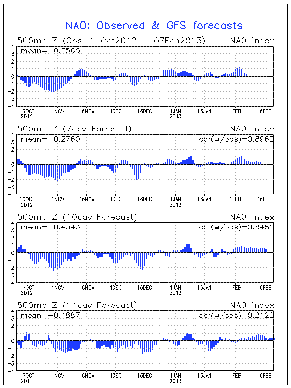
The NAO index has been strongly positive for the last week or so but is trending downward. The GFS is forecasting a slightly positive NAO for the next 2 weeks. The AO index has been positive but now is trending more negative in the last few days and is forecast to remain negative for the next two weeks.
It is interesting to note that this winter has been characterized by a strong, persistent vortex over central Canada that has maintained a fast airflow across Canada and the northern half of the nation. This pattern results in a colder, but relatively dry flow of air for the Northeast since the cold air is pushed eastward off the eastern coast of Canada and is not able to move southward into the lower 48 states. However, up examination of some of the larger snow storms that occurred in 2010 or 2011, the flow becomes much slower over Canada without that strong vortex feature we have seen most of this winter. This is what is occurring now. The flow in Canada is slower and we have a major winter storm forecast to impact the Northeast.
George Wright is a Certified Consulting Meteorologist for Wright Weather Consulting, LLC. George is also a meteorologist with ABC News and Cablevision News 12. Our website is WrightWeather.com.