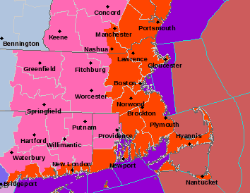
Low pressure tracking through the Great Lakes will reform and intensity rapidly south of Long Island tonight with strong winds, heavy snow, blowing and drifting snow, dangerous wind chills and potential power outages. Between 2 and 4 inches of snow is expected in New York City with up to a foot in coastal New England including Boston. Boston already has a record 42.3 inches of snow so far this month with more on the way. Brutal wind chills to 10 to 25 below zero can be expected Sunday night and Monday. In New York City, it will be the cold air since 1994 when the temperature in Central Park plunged to -2 on January 19, 1994. A Winter Weather Advisory is in effect for New Jersey and the New York City metro area with a Blizzard Warning for Suffolk County Long Island and southeast coastal Connecticut. A High Wind Warning for gusts to 60 mph is in effect for the New York City metro area including New Jersey, Nassau County and the Lower Hudson Valley. The long range GFS model is hinting at a coastal storm for Tuesday night and Wednesday that could graze the Northeast with some snow. This storm is forecast to produce snow, sleet, freezing rain and rain over the Southeast this weekend into early next week. Another storm could impact the Southeast and then the Northeast with wintry precipitation next weekend.
George Wright is a Certified Consulting Meteorologist for Wright Weather Consulting, LLC. Visit our website at WrightWeather.com. Follow George Wright on Twitter @gwweather.