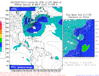
The latest 5 AM NHC official track is indicating that the storm is forecast to make landfall with hurricane force winds (> 74 mph) near 2 AM on Tuesday near Cape May, NJ. The hurricane models (GFDL, CMC, NOGAPS, etc.) as well as the European, NOGAPS, UKMET and the NAM are all bringing the storm to the New Jersey coast or across the Delaware Coast early on Tuesday. The model outlier right now is the CMC model which tracks the storm into the New England coast. The pressure forecast by the GFDL model is extraordinarily low at 28.27 inches just before landfall on Tuesday. The GFS model is forecasting a an extremely low pressure as well - 28.23 inches when it is located south of Long Island on Tuesday. The NAM is forecasting a central pressure of 28.47 inches also when it is forecast to be in a position south of Long Island. There is a strong blocking pattern with a ridge of high pressure east and north of the storm in the western Atlantic that is keeping the storm near the coast. Meanwhile, a cold front to the west will gradually become stationary in the next 36 to 48 hours along the east coast. A strong jet stream to the west will dig down from Canada and the Midwest that will provide upper level divergence to Sandy and either strengthen it or at least maintain its strength as it then brings it back (i.e, retrograde motion) westward towards the coast. Looking back at the central pressure for the very strong and damaging March 2010 storm in the New York City metro area, the barometric pressure was in the range of about 29.35 inches or about 994 millibars.
George Wright is a Certified Consulting Meteorologist for Wright Weather Consulting, LLC. George is also a meteorologist with ABC News and Cablevision News 12. Our website is WrightWeather.com. Follow George on Twitter during Sandy.


