skip to main |
skip to sidebar
Models in Dissagreement on Next's Week's Potential East Coast Storm
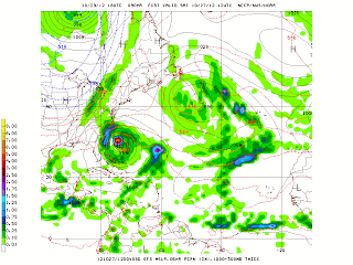
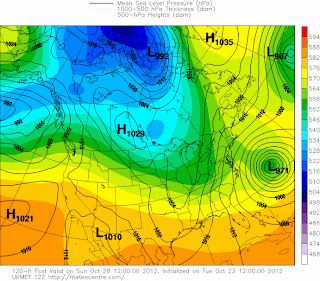
The GFS model continues to push tropical cyclone Sandy northeastward into the north Atlantic next week. The model does not forecast the capturing of the tropical cyclone by an intense trough at 500 mb. The UKMET and MRF models are also forecasting this offshore track. However, the European model (ECMWF) and the Navy NOGAPS models continue to forecast what the GFS was forecasting a day or so ago: a very strong coastal low that tracks northwestward into the New York City metropolitan region on Monday and Tuesday of next week. In this scenario, a major storm would impact most of southern New England and all of the New York City metro area . This storm, if it forms, would bring flooding rains, coastal flooding and strong winds. The timing of the trough that is tracking in from the west will determine whether or not it will phase in with Sandy. If the timing is just right, the trough could entrain the moisture from the storm into it and then capture it bringing it towards the coast and intensifying it as it advects upper-level positive vorticity and provides strong upper-level divergence. Model agreement will be monitored over the next several days and the forecast will become clearer by this Friday or Saturday.
Meanwhile, the current average 500 mb pattern forecast by the ECMWF over the next 8 to 10 days is indicated strong blocking over the western Atlantic and Greenland indicative of a negative phase of the North Atlantic Oscillation (NOA). It is interesting to note that the GFS is hinting at an early snowfall in parts of the New York City metro area on November 8th. Of course all of this is very early and will likely change in future runs. However, it is interesting and important to note the trends the GFS is forecasting. Since this model has performed amazingly well in forecasting the general weather trends, i.e., warm or cool, wet or dry, etc. the last few winters as much as 12 to 16 days in advance so it is worth taking a look at these runs.
George Wright is a Certified Consulting Meteorologist for Wright Weather Consulting, LLC. George is also a meteorologist with ABC News and Cablevision News 12. Our website is WrightWeather.com. Follow George Wright on Twitter.


